 For the last week or so we have been trying to decide which route to take to make the long journey across the entire width of Mozambique to Malawi. We knew we were in for a coupe of days of long travelling, but weren’t sure what the roads were like.
Option 1 – Head back south to Nampula and take the road west through Cuamba to the border at Mandimba. This meant retracing our steps for quite some distance, although we knew the road to Nampula at least was pretty good. General opinion from the locals was that the road west wasn’t too good, although probably better than the west road further north.
Option 2 – Head back to Pemba then take the road west through Montepuez and Lichinga and then head south to the border at Mandimba. The local opinion was that this road was dreadful and we should not take it. We spoke to a Dutch couple who had travelled the road about 3 weeks earlier and a group of South Africans with 4 cars and trailers who had done the road about a week ago. They all said it was doable, but slow and all of them got stuck at one point. We only had to retrace our steps back to Pemba, so the route would be new, but we were not sure where we could overnight along the way.
Option 3 – Head even further south, past Nampula to Mocuba and then take the road west to the Milange border. This meant retracing our steps even further and having to endure the hour of really bad road north of Mocuba again. Local opinion was that this was the easiest option.
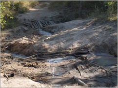 We went for option 2 – nothing like an adventure! We left Pangane at 6.15am and headed for the tar road, not looking forward to the muddy section again, although this time it would be downhill at least. We were pleasantly surprised to find that a day of sunshine had managed to dry the road out almost completely and there was no sign of any slipperiness. The road all the way to Montepuez is excellent tar, but it then stops in the middle of town and turns to dirt. The road to Marrupa is then a mixture of ok, bad and really bad dirt. At times the road almost
 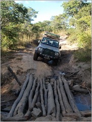 disappears, particularly around villages and you definitely need a 4wd. It took us nearly 6 hours to do just over 200km from Montepuez to Marrupa. It was slow going, but it was quite a pleasant drive with changing scenery, passing through very rural villages where everyone was friendly, waving to us whilst staring for us long as they could see us. We passed through some small water crossings, one large water crossing, over bridges made from tree trunks laid over the river, one of which was only just wide enough for our car, around sections of road that were washed away, over, up and down gullies, through sand and a little bit of mud, all without getting stuck! Yay! (We could see though a number of places where people had been stuck, the mud had been thick and where the road had been built up with branches and rocks. Things had obviously dried out quite a lot in the last week, which we were very thankful for).
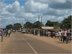 We were getting closer to Marrupa but were not sure we would make it before dark as we didn’t know how much longer the really bad road would last. It gets dark really quickly here at the moment and by 5.30pm it is dark and driving in the dark is not something you want to do. Even if we did make we weren’t entirely sure where we were going to stay anyway. We finally managed to get through to another South African couple we met in Pemba who had done the road a couple of days earlier and found out where they stayed. At 5.15pm we pulled into Quinta Manlia about 4km south of Marrupa (nothing like cutting it fine) to be met by George the owner where we could camp for a total of 200Mtc for 2 (about $6.50). George is setting up a basic, but quite nice place and he proudly showed us the 2 chalets he has, both of which were clean and fine, the new chalets still being built, his restaurant and bar and even that he had beer in the fridge. Again the toilet is a just the bowl flushed with water scooped from a container, but it was clean and the shower is cold water from a bucket. It was a perfectly adequate and secure place to stop for the night just in the right location for people travelling the northern route across the country.
We were up early again today as we had another long day’s drive and were hoping to make it across the border to Malawi and then to Liwonde National Park. The worst of the road was definitely over. The road from Marrupa to Lichinga is narrow tar, but in good condition so we covered the distance in a reasonably short time. The road south from Lichinga to the border at Mandimba was dirt that was in OK condition.
Mandimba border is the most laid back, simple border we have encountered – no gate passes, no queues, no hassle. After driving down a dirt track we came across a barrier that blocked the road with a building to one side. We went inside and a pleasant, chatty official took our Temporary Import Permit and that was customs done. We filled in the immigration forms and the other guy stamped our passports. Too easy! We alo managed to change the rest of our Meticas into Malawi Kwatcha at a fair rate, although the money changers need to get their hundreds and thousands sorted out. The only way to work out the exchange rate was to physically show them some Meticas and then they showed you the equivalent in Kwatcha.
We then drove the dirt track from the Mozambique border, through a village and to the Malawi border. The Malawi border was just as easy. We filled in our immigration forms, passport stamped and then customs filled in the Carnet for our car for the first time, and they even knew how to do it which was a bonus. We filled in the details of the car in another book and then went outside to purchase insurance. All the buildings were empty, but someone phoned one of the insurance agents who then turned up a few minutes later. 6000 kwatcha later and we were sorted. I was dying to go to the loo, so I asked one of the customs guys if there was one. No problem, just come around the side through the door, into the “restricted” customs area, through their office and use the staff toilets. Just like in Australia – not!
So we are now in Malawi and on our way to Liwonde National Park.
